OPK Sundvollen

, |SHOW ON MAP|
Sundvollen
Contact: ledern (youknowit) opk.no
05:04-21:45 (CEST)
Min. certification: PP2/SP2
Max. altitude (TMA): 914 m.a.s.l.
Take-off altitude: 390 m.a.s.l. (285 m top-to-bottom).
Orientation: WSW-NNE
Note: Expect turbulence in southerly winds.
Parking: Parking along the road is prohibited. Use only designated parking areas.
Road toll: Pay the road toll at each passage.
Unpacking: Unpack your glider in the parking area to avoid obstructing other pilots at take-off.
Aerial sporting box: The Sundvollen box can only be used when activated according to standard operating procedure.
Radio frequency (NLF): 154.175 MHz
LANDING
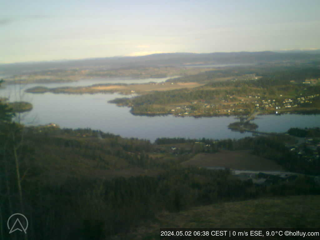
Landing: During growing season landings are limited to the designated area (see photo). Land as close to the field edge as possible. Always take the shortest way out of the field. Landing on the school’s parking lot is prohibited.
Note: Trees around the field creates turbulence in high winds. Be aware of children playing near by.
Parking: The school’s parking lot is only for loading and unloading. The road barrier could be closed without notice. Please park at Nedre Kleiva parking, abt. 100 meters past the school road.
Packing: Leave the landing field quickly. Pack your glider in the parking area.
Sundvollen
Contact: ledern (youknowit) opk.no
05:04-21:45 (CEST)
Min. certification: PP2/SP2
Max. altitude (TMA): 914 m.a.s.l.
Take-off altitude: 390 m.a.s.l. (285 m top-to-bottom).
Orientation: WSW-NNE
Note: Expect turbulence in southerly winds.
Parking: Parking along the road is prohibited. Use only designated parking areas.
Road toll: Pay the road toll at each passage.
Unpacking: Unpack your glider in the parking area to avoid obstructing other pilots at take-off.
Aerial sporting box: The Sundvollen box can only be used when activated according to standard operating procedure.
Radio frequency (NLF): 154.175 MHz
LANDING
Landing: During growing season landings are limited to the designated area (see photo). Land as close to the field edge as possible. Always take the shortest way out of the field. Landing on the school’s parking lot is prohibited.
Note: Trees around the field creates turbulence in high winds. Be aware of children playing near by.
Parking: The school’s parking lot is only for loading and unloading. The road barrier could be closed without notice. Please park at Nedre Kleiva parking, abt. 100 meters past the school road.
Packing: Leave the landing field quickly. Pack your glider in the parking area.
Page views in 2026: 788347
Note: Calculé à partir des données annuelles lorsque la vitesse moyenne du vent est supérieure à 4 km/h.
Loading...
Moyennes Mise à jour: 12:18:52 Mon CEST
| Date/Heure | 04:30 | 04:45 | 05h | 05:15 | 05:30 | 05:45 | 06h | 06:15 | 06:30 | 06:45 | 07h | 07:15 | 07:30 | 07:45 | 08h | 08:15 | 08:30 | 08:45 | 09h | 09:15 | 09:30 | 09:45 | 10h | 10:15 | 10:30 | 10:45 | 11h | 11:15 | 11:30 | 11:45 | 12h | 12:15 |
| Vitesse | 5.3 | 4.7 | 3.3 | 3.3 | 4.2 | 2.5 | 2.5 | 2.5 | 3.1 | 3.6 | 4.2 | 2.8 | 1.9 | 2.8 | 3.1 | 3.3 | 3.9 | 2.8 | 2.8 | 2.5 | 2.2 | 3.6 | 3.6 | 3.6 | 3.1 | 2.2 | 2.2 | 1.9 | 1.4 | 2.2 | 2.8 | 2.8 |
| Rafales (m/s) | 7.5 | 7.8 | 5.3 | 5.6 | 6.1 | 5.6 | 4.2 | 4.4 | 4.4 | 5.8 | 6.1 | 4.2 | 2.8 | 4.7 | 4.7 | 5.3 | 6.1 | 5.3 | 4.7 | 4.4 | 4.2 | 6.1 | 5.8 | 5.8 | 6.1 | 3.6 | 4.7 | 3.9 | 4.4 | 4.2 | 6.1 | 5.3 |
| Direction | ||||||||||||||||||||||||||||||||
| Direction Degrés | WNW 289° | WNW 297° | WNW 289° | W 275° | WNW 283° | WNW 291° | W 273° | WNW 293° | WNW 285° | W 281° | WNW 291° | WNW 287° | WNW 288° | WNW 282° | W 268° | W 263° | W 279° | WNW 288° | W 270° | W 264° | W 266° | W 273° | W 276° | W 279° | W 277° | W 260° | W 269° | WSW 248° | WSW 246° | W 262° | WNW 287° | W 272° |
| Temp. (°C) | 10.6 | 10.4 | 10.1 | 10.1 | 10.2 | 9.9 | 9.8 | 9.7 | 9.7 | 9.9 | 10.0 | 9.7 | 9.7 | 9.7 | 10.0 | 10.1 | 10.3 | 12.3 | 13.1 | 13.7 | 13.9 | 13.4 | 13.2 | 13.2 | 13.2 | 13.5 | 13.7 | 14.4 | 14.9 | 14.7 | 15.0 | 15.3 |
| Date/Heure | 21h | 22h | 23h | Sun | 01h | 02h | 03h | 04h | 05h | 06h | 07h | 08h | 09h | 10h | 11h | 12h | 13h | 14h | 15h | 16h | 17h | 18h | 19h | 20h | 21h | 22h | 23h | Mon | 01h | 02h | 03h | 04h |
| Vitesse | 3.3 | 3.1 | 2.5 | 2.8 | 3.3 | 3.3 | 3.3 | 1.4 | 1.1 | 0.3 | 1.7 | 1.4 | 0.8 | 1.4 | 2.2 | 1.7 | 1.9 | 1.9 | 2.8 | 4.4 | 4.2 | 5.6 | 5 | 5.3 | 5.8 | 5.6 | 5.6 | 4.7 | 4.2 | 4.4 | 5 | 2.8 |
| Rafales (m/s) | 6.4 | 5.8 | 5.3 | 5.6 | 5.6 | 6.4 | 6.4 | 5.3 | 3.9 | 2.2 | 3.9 | 3.9 | 3.6 | 4.7 | 4.7 | 4.7 | 4.7 | 4.2 | 7.5 | 8.1 | 7.8 | 9.2 | 8.6 | 8.6 | 8.9 | 9.7 | 10.6 | 10.3 | 7.8 | 7.8 | 7.5 | 7.5 |
| Direction | ||||||||||||||||||||||||||||||||
| Direction Degrés | SSE 154° | SSE 158° | SW 223° | W 262° | WSW 242° | SW 233° | WSW 250° | SW 217° | SSW 195° | S 170° | S 181° | S 185° | W 275° | NW 306° | W 278° | NW 310° | W 278° | W 272° | WNW 290° | WNW 284° | NW 304° | WNW 286° | WNW 300° | WNW 299° | WNW 284° | WNW 291° | WNW 293° | WNW 287° | WNW 289° | WNW 285° | W 273° | WNW 297° |
| Temp. (°C) | 14.1 | 13.6 | 13.7 | 13.1 | 12.4 | 11.8 | 11.7 | 10.8 | 10.4 | 9.7 | 10.6 | 11.7 | 12.6 | 14.0 | 14.4 | 15.7 | 16.1 | 16.3 | 18.1 | 18.2 | 18.8 | 18.0 | 18.6 | 17.9 | 16.7 | 14.9 | 13.5 | 12.8 | 12.1 | 11.6 | 11.3 | 10.4 |
Graphiques
ZOOM
3 h
6 h
12h
1 d
5 d(max)
Zoom synchronisé
Mise à jour: 12:18:52 Mon CEST
- Vent vitesse, rafales (m/s)
- Direction du vent (°deg)
- Température (°C)
- Luminosité
Faites défiler ou cliquez ici pour charger les graphiques
Faites défiler ou cliquez ici pour charger les graphiques
Faites défiler ou cliquez ici pour charger les graphiques
Faites défiler ou cliquez ici pour charger les graphiques