CIC Hut Ben Nevis

Scotland, Lochaber, 680m (AMSL) |SHOW ON MAP|
Ben Nevis, Charles Inglis Clark Memorial Hut (Scottish Mountaineering Club)
https://www.smc.org.uk/
04:53-21:59 (BST)
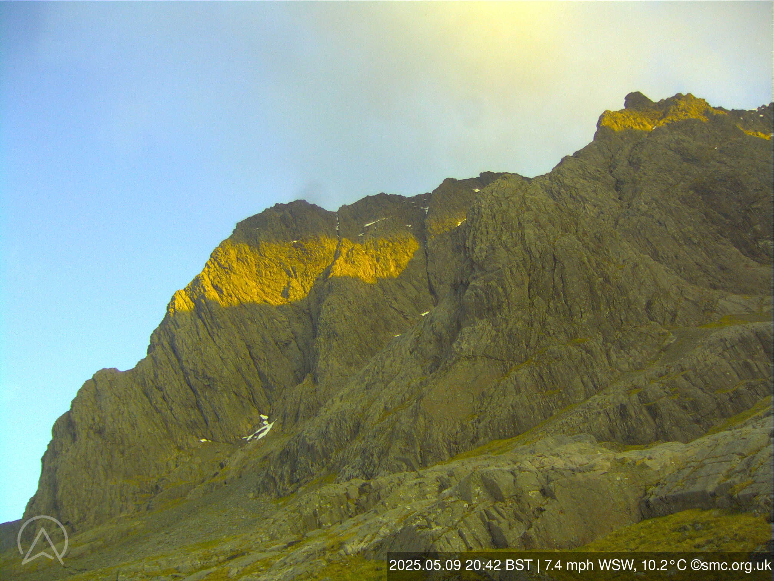
The CIC webcam and weather station is located at the Charles Inglis Clark Memorial Hut (the CIC Hut) on Ben Nevis, owned and operated by the Scottish Mountaineering Club (SMC). The installation of the webcam and weather station was funded by the SMC and the Scottish Mountaineering Trust; operating costs are borne by the SMC.
Ben Nevis, Charles Inglis Clark Memorial Hut (Scottish Mountaineering Club)
https://www.smc.org.uk/
04:53-21:59 (BST)
The CIC webcam and weather station is located at the Charles Inglis Clark Memorial Hut (the CIC Hut) on Ben Nevis, owned and operated by the Scottish Mountaineering Club (SMC). The installation of the webcam and weather station was funded by the SMC and the Scottish Mountaineering Trust; operating costs are borne by the SMC.
Page views in 2026: 59119
Note: Calculated from yearly data where the average wind speed is more than 4km/h.
Loading...
Durchschnitt : 22:45:24 Fri BST
| Zeit | 15h | 15:15 | 15:30 | 15:45 | 16h | 16:15 | 16:30 | 16:45 | 17h | 17:15 | 17:30 | 17:45 | 18h | 18:15 | 18:30 | 18:45 | 19h | 19:15 | 19:30 | 19:45 | 20h | 20:15 | 20:30 | 20:45 | 21h | 21:15 | 21:30 | 21:45 | 22h | 22:15 | 22:30 | 22:45 |
| Geschw. | 16 | 12 | 14 | 12 | 18 | 14 | 20 | 15 | 11 | 8 | 12 | 10 | 6 | 12 | 6 | 9 | 9 | 10 | 12 | 10 | 8 | 9 | 8 | 9 | 10 | 6 | 10 | 13 | 14 | 7 | 6 | 7 |
| Böen (km/h) | 31 | 24 | 29 | 24 | 34 | 25 | 36 | 31 | 19 | 17 | 21 | 19 | 12 | 24 | 15 | 20 | 22 | 20 | 22 | 19 | 18 | 19 | 21 | 19 | 19 | 13 | 16 | 24 | 24 | 15 | 12 | 14 |
| Richtung | ||||||||||||||||||||||||||||||||
| Richtung Deg. | NNO 19° | NNO 20° | NNO 16° | N 8° | NNO 18° | NNO 26° | NNO 26° | NNO 28° | NNO 24° | NO 44° | NNO 30° | NO 54° | ONO 68° | NNO 17° | NNO 14° | NO 36° | NO 38° | NO 46° | N 8° | NNO 13° | NNO 13° | NNO 16° | NNO 26° | NNO 16° | N 10° | NO 46° | NNO 16° | NNO 26° | NNO 18° | N 354° | N 3° | ONO 61° |
| Luftfeucht (%) | 47.5 | 53.4 | 57.7 | 50.9 | 45.9 | 48.8 | 49.6 | 52.7 | 51.0 | 58.7 | 61.1 | 69.1 | 70.1 | 73.8 | 78.1 | 80.2 | 87.4 | 96.4 | 100.0 | 100.0 | 100.0 | 100.0 | 100.0 | 100.0 | 100.0 | 100.0 | 100.0 | 100.0 | 100.0 | 100.0 | 100.0 | 100.0 |
| Temp. (°C) | 18.9 | 19.5 | 19.4 | 21.2 | 19.4 | 18.7 | 18.2 | 18.7 | 19.4 | 18.4 | 19.1 | 17.7 | 17.2 | 17.1 | 16.9 | 16.9 | 16.9 | 16.9 | 16.7 | 16.7 | 16.4 | 16.1 | 16.3 | 16.9 | 16.7 | 16.0 | 15.6 | 14.8 | 14.4 | 14.1 | 13.7 | 13.7 |
| Zeit | 07h | 08h | 09h | 10h | 11h | 12h | 13h | 14h | 15h | 16h | 17h | 18h | 19h | 20h | 21h | 22h | 23h | Fri | 01h | 02h | 03h | 04h | 05h | 06h | 07h | 08h | 09h | 10h | 11h | 12h | 13h | 14h |
| Geschw. | 7 | 10 | 5 | 1 | 4 | 3 | 9 | 11 | 9 | 10 | 10 | 11 | 11 | 11 | 10 | 9 | 6 | 5 | 8 | 9 | 5 | 5 | 3 | 7 | 3 | 3 | 2 | 5 | 4 | 5 | 8 | 14 |
| Böen (km/h) | 14 | 12 | 10 | 7 | 8 | 9 | 18 | 26 | 24 | 22 | 26 | 23 | 25 | 27 | 20 | 19 | 19 | 16 | 22 | 23 | 14 | 10 | 10 | 11 | 9 | 8 | 8 | 10 | 16 | 22 | 21 | 25 |
| Richtung | ||||||||||||||||||||||||||||||||
| Richtung Deg. | S 184° | SSW 212° | SW 223° | NNW 332° | NNW 341° | N 359° | N 10° | NNO 21° | NNO 20° | NNO 25° | NNO 25° | NNO 25° | NNO 30° | NO 53° | ONO 60° | NO 48° | N 353° | N 350° | NNO 24° | NNO 28° | ONO 65° | SSO 161° | SSO 164° | SW 216° | WSW 241° | W 267° | WNW 287° | NNW 342° | N 3° | NNW 340° | N 353° | N 10° |
| Luftfeucht (%) | 65.7 | 73.2 | 73.3 | 58.4 | 58.0 | 48.8 | 28.4 | 34.3 | 34.1 | 32.3 | 32.6 | 35.6 | 37.2 | 42.2 | 54.7 | 62.7 | 66.2 | 66.6 | 63.8 | 62.7 | 66.9 | 73.9 | 98.3 | 99.7 | 100.0 | 100.0 | 1.0 | 100.0 | 94.9 | 62.8 | 56.3 | 52.7 |
| Temp. (°C) | 17.1 | 16.9 | 17.7 | 22.4 | 24.6 | 25.2 | 26.1 | 24.4 | 25.1 | 24.9 | 24.1 | 23.3 | 21.8 | 20.9 | 20.2 | 19.6 | 18.5 | 17.5 | 17.6 | 17.5 | 16.1 | 15.4 | 14.0 | 13.5 | 13.6 | 11.9 | 10.2 | 16.1 | 17.8 | 19.8 | 20.6 | 20.1 |
Graphen
ZOOM
3 h
6 h
12h
1 d
5 d(max)
syncronisiertes Zoom
: 22:45:24 Fri BST
- Geschwindigkeit (km/h)
- Windrichtung (°deg)
- Temperatur & Taupunkt (°C)
- Luftfeuchtigkeit (%)
Scroll down or click here to load graphs.
Scroll down or click here to load graphs.
Scroll down or click here to load graphs.
Scroll down or click here to load graphs.